


Page 18 - sst_class_06
P. 18
Linear Scale
             2. Direction : In order to find, where you are going and how far away it is, you need to know

             what direction you are going and need to be able to figure out the distance between the
             place you are and the place you are going to. The easiest way to know the directions is that
             the earth rotates west to east, so the sun rises in the east and sets in the west. No matter
             which side one is facing. East is the morning sun and west is the evening sun or night time.

             A compass is a device that helps the user to know the direction of a place.
             The earth actually behaves as a giant magnet with a north magnetic pole and
             a south magnetic pole. If a magnet is allowed to swing freely on a string, it
             will eventually line up in a north-south position in alignment with the north
             and south poles of the earth. Compass is used to find out main directions as
             its magnetic needle always points towards north-south direction.
                                                                                                           Compass
                                There are four major directions—North, South, East and West, also called

                                Cardinal points. Other four intermediate directions are north-east (NE),
                                south-east (SE), south-west (SW) and north-west (NW), which help us to
                                locate places more accurately.

              Cardinal Directions

             3. Symbols : Symbols and signs are very important in a map because maps are drawn on
             a small sheet and it is not practically possible to write the names of things such as road,
             bridge, river, school, hospital, temple, mountain, etc. on them. Certain symbols and signs
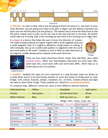
             are used to show these things. These symbols are called the conventional symbols.
             In a physical map, different colours are used to show different physical features.

             Cultivated area       –  Yellow,                            Grassland                  –  Light green

             Forests               –  Dark green,                        Uncultivated land          –  Brown

             Water features        –  Blue                               Built up area i.e.,        –  Red

                                                                         village, sites, towns, roads, etc.


              18                                                                                         Social Studies-6

